


laille et lArgens

aljac
User

Length
5 km

Max alt
176 m

Uphill gradient
149 m
Km-Effort
7 km

Min alt
29 m

Downhill gradient
156 m
Boucle
Yes
Creation date :
2019-01-15 19:58:54.783
Updated on :
2019-01-15 19:58:54.783
1h40
Difficulty : Unknown

FREE GPS app for hiking
 SityTrail
IGN / Geographical institutes
SityTrail Plus
The world is yours!
About
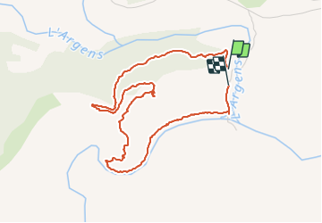
Trail Other activity of 5 km to be discovered at Provence-Alpes-Côte d'Azur, Var, Les Arcs-sur-Argens. This trail is proposed by aljac.
Positioning
Country:
France
Region :
Provence-Alpes-Côte d'Azur
Department/Province :
Var
Municipality :
Les Arcs-sur-Argens
Location:
Unknown
Start:(Dec)
Start:(UTM)
298512 ; 4812182 (32T) N.
Comments